MAOP VALIDATION (MAOP) MODEL
Maximum Allowable Operating Pressure (MAOP) and Maximum Operating Pressure (MOP) are the two most important safety criteria for gas and liquid pipelines respectively. Integrity Plus offers a fit-for-purpose model for recalculating MAOP/MOP per the latest §192 and §195 requirements. Presented spatially or tabularly, the results include a comparison between calculated and previously established MAOP/MOP and the identification of limiting factors. Users can perform What-If analysis to address any identified issues. This model runs on New Century’s Spatial Risk Analyst platform and it is available for purchase(1) or as a service.
Spatial Risk Analyst connects directly to asset data sources (PODS, UPDM, GIS) and other compatible sources to seamlessly integrate all information required for calculating MAOP/MOP. Design Pressure is calculated using the appropriate safety factor, which may vary based on class location(2), facility boundaries, or crossing information. The model also evaluates MAOP established through pressure testing, highest actual operating pressure history, maximum safe pressure, or alternative maximum allowable operating pressure.
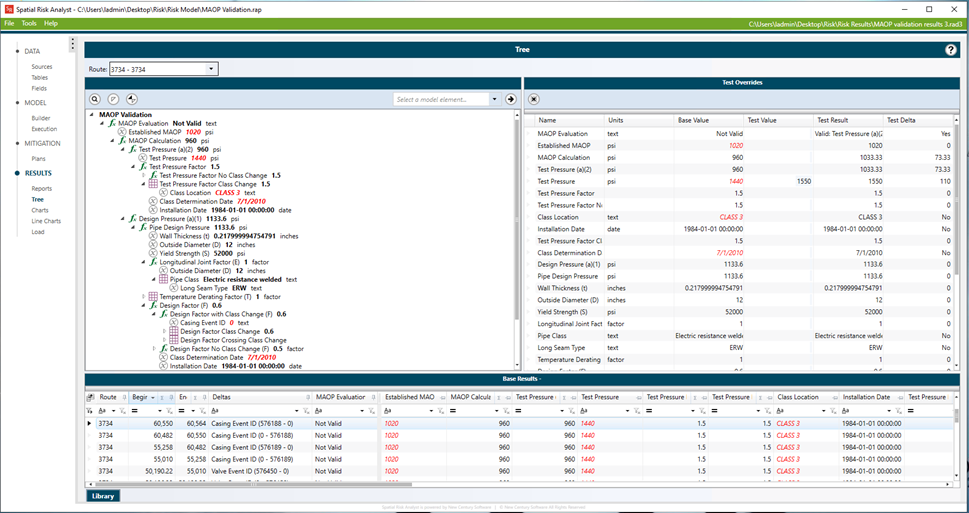
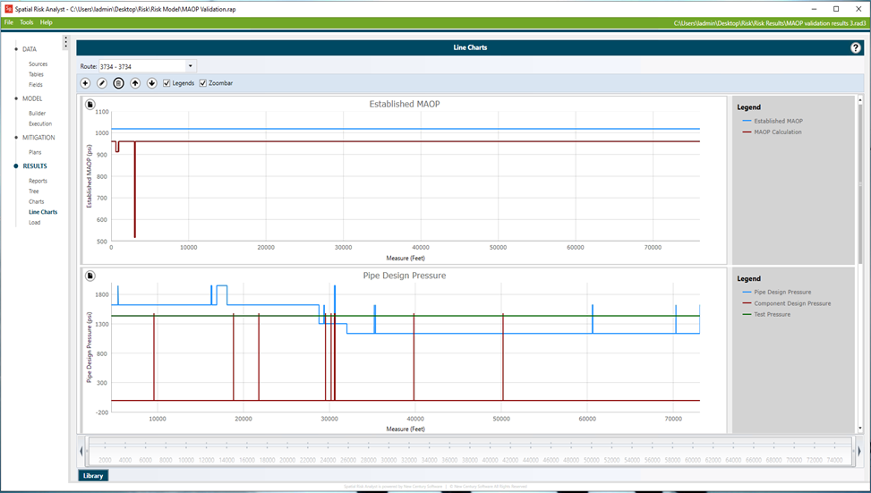
SRA’s line charting features allow the entire route to be reviewed efficiently. The established MAOP/MOP can be compared to the calculated MAOP/MOP to identify areas of concern. SRA’s line charting features allow the entire route to be reviewed efficiently. Once the limiting factor is identified, a What-If analysis can be used to evaluate options to address the concern.
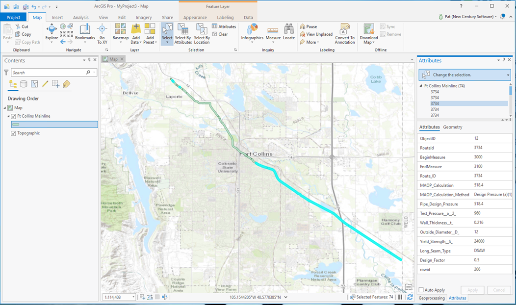
Areas, where MAOP/MOP is not commensurate with code requirements, can be exported as a feature class for generating maps and dashboards that help communicate areas of concern and aid in the planning of mitigation initiatives.
SUPPORTING SERVICES
Our service team can also support the following activities that are critical to the accurate determination of MAOP:
- Establishing Traceable, Verifiable, and Complete Records
- Positive Material Identification (PMI) (available through MISTRAS NDT)
- Class Location analysis to ensure appropriate safety factors are used
- Special Permits submissions for class location waivers
(1) The purchased model is subject to a license agreement and requires a licensed copy of Spatial Risk Analyst to run.
(2) New Century Software’s Gas HCA product may be used to update Class Locations prior to performing an MAOP/MOP verification.
Validate compliance with MAOP/MOP code requirements:
- Evaluate TVC status of critical records required for MAOP reconfirmation
- Calculate MAOP/MOP per §192 and §195 requirements
- Identify areas where MAOP/MOP is not commensurate with code
Identify the most cost-effective mitigation approach:
- Quickly and easily identify limiting factors
- Investigate and test different mitigation approaches using What-If analysis
- Create mitigation plans to organize mitigation activities.
- Revalidate MAOP/MOP based on planned activities.
Visualize the status of your MAOP/MOP program through maps and dashboards:
- Identify sections that require TVC data
- Identify sections where MAOP/MOP has been reconfirmed
- Identify sections where MAOP/MOP is not commensurate with code, any temporary restrictions in place, and pending mitigations planned
Some key features of the MAOP Validation Model include:
- Integrates data from multiple distributed data sources
- Processes both tabular and spatial data types
- Calculates design pressure based on material properties
- Calculates MAOP/MOP required based on the class location safety factor
- Compares established to calculated MAOP/MOP
- Identifies limiting factors affecting MAOP/MOP at specific locations
- Allows What-If analysis to investigate mitigation options for a specific location
- Create and evaluate broad mitigation plans for large sections of a pipeline
- Exports feature classes to identify issues on a map or dashboard
- Ease of use allows running periodically to monitor changes throughout the year
Model requires Spatial Risk Analysis 3.0 or greater
Support data sources include:
- MS SQL Server, Oracle, MS Access, SQLite (tabular)
- File geodatabase, SDE, ArcRuntime, Feature Services (tabular or spatial)